
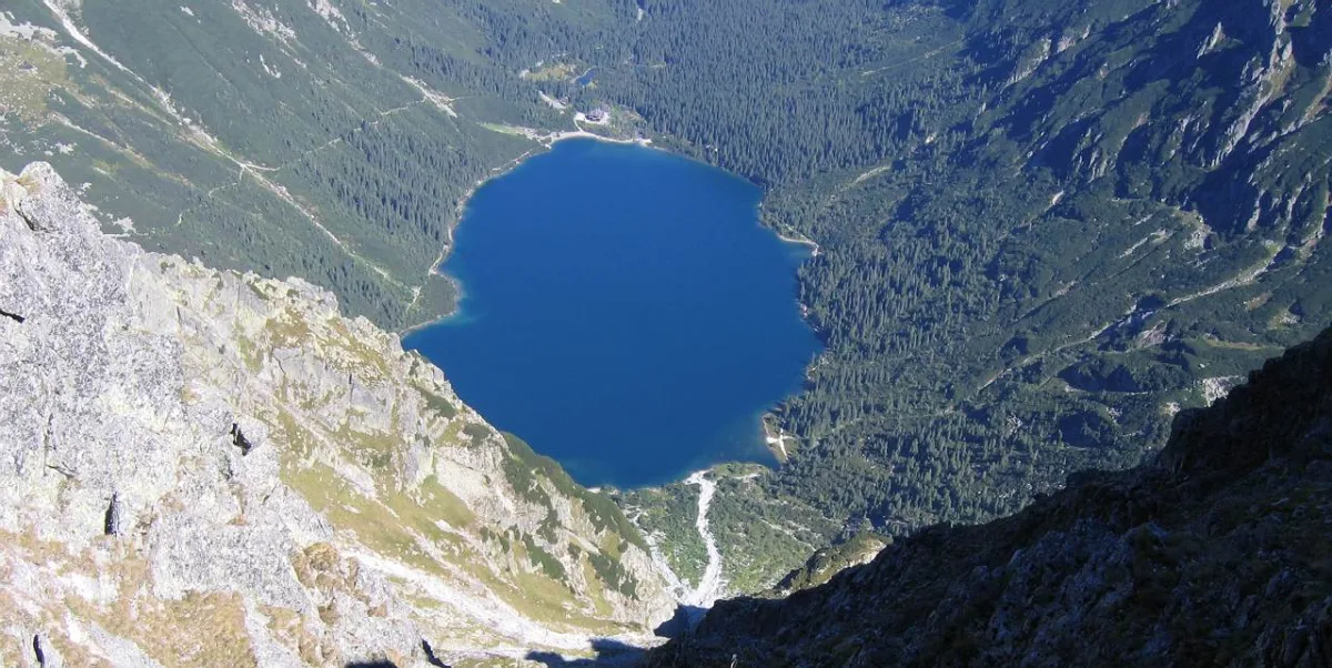
At Morskie Oko three threads meet that seldom end up in a single description: the measurements of the lake, the long dispute over which side of the border it lies on, and two mountain hut buildings standing side by side on the moraine ridge. Below, in turn, with the places where the sources differ marked.
The lake: dimensions that changed with measurement
Morskie Oko lies in the Rybi Potok Valley at an altitude of 1,395 m above sea level. According to Wikipedia it has an area of 34.93 ha, a length of 862 m and a width of about 568 m. It is a glacial lake, closed on the north by a ridge of terminal moraine. It is fed by two permanent streams, the Czarnostawiański and the Mnichowy, and the Rybi Potok flows out of it.
The depth has been given differently, depending on the era and the method. Measurements by the Military Geographical Institute in April 1934 gave 50.8 m, the studies of Adam Choiński in 1999 gave 51.8 m, and two echo-sounder soundings of 2012 gave 50.8 and 50.4 m respectively. The first bathymetric plan was drawn up in 1879 by Eugeniusz Klemens Dziewulski, who calculated about 49.5 m.
The ranking thread requires caution. The 1934 measurements gave the lake a larger area than Wielki Staw, but their author stipulated that the difference did not settle the matter, because Morskie Oko was measured at a very high water level, and Wielki Staw with an ice cover lying on it. According to modern studies Morskie Oko is the second lake of the Tatras by area, about 1.5 ha smaller than Wielki Staw. This is why Morskie Oko is not written about without the qualification that it is the largest lake of the Tatras.
The name is a translation from German. Earlier the highlanders called the lake Biały Staw (White Pond), which was recorded in 1650, or Rybie Jezioro (Fish Lake). A legend known from 18th-century texts, among others by Benedykt Chmielowski, tells of an underground connection with the sea, even with the Adriatic. This is a tale, not a fact, and those sources stress that the depth of the lake could not then be measured.
The border dispute decided by a court in Graz
The Tatra boundaries between Poland and Hungary were the subject of disputes from the end of the 16th century, and the first claims concerned Podhale. In the 19th century the weight shifted to Morskie Oko. The former estates around the lake were bought in 1824 from the Austrian authorities by Emanuel Homolacs, and in 1889 the Zakopane estates together with the Rybi Potok Valley were acquired at auction by Count Władysław Zamoyski. On the other side of the border the Jaworzyna estate belonged from 1879 to Prince Christian Hohenlohe.
The climax of the conflict fell, according to Wikipedia, in the years 1890-1901. Both sides tried to make economic use of the disputed land: felling of trees, grazing, hunting. In addition there were obstacles for tourists, for example destroyed footbridges and paths. An Austrian map of 1880 ran the border through the middle of the lake, and the Hungarian side wanted it to run from Rysy through Czarny Staw and Morskie Oko to the Rybi Potok.
In 1901 the Austrian and Hungarian authorities set up an international arbitration court in Graz. The interests of Galicia and of Zamoyski were represented by Prof. Oswald Balzer, and the judge on the Austrian side was Aleksander Mniszek-Tchorznicki. The ruling of 13 September 1902 awarded Galicia almost all the disputed lands. The sources do not agree on the composition of the court: the entry on the lake indicates Mniszek-Tchorznicki as chairman, while the entry on the dispute itself speaks of a chairman from Switzerland and of Tchorznicki as the judge of the Austrian side. Here we adopt the second version, because it is more detailed.
Linked with this was the road from Zakopane to the lake, named after Balzer. Its construction was completed in 1902. The section from Palenica Białczańska to Morskie Oko is closed to private cars.
Two mountain huts and a long history of fires
By the lake stand two buildings that are often confused in descriptions. Today's PTTK Mountain Hut at Morskie Oko consists of an old and a new part. The new hut was built in 1908 by the Tatra Society. Right next to it stands the Old Mountain Hut, which was built in 1891 as a coach house.
The beginnings are disputed in detail. The entry on the hut states that the earliest mentions of a shelter date from 1823, and the first building was put up in 1827 by Emanuel Homolacs. The entry on the lake speaks of a first hut from 1836. Both versions agree that the building burned down in 1865. The wooden hut of the Tatra Society was opened on 3 August 1874, and on 16 September 1875 it was named after Stanisław Staszic, on the initiative of Leopold Świerz. Wikipedia writes that Adam Asnyk and Helena Modrzejewska were at the opening. On the night of 1 to 2 October 1898 this building also burned down, and the role of the hut was taken over by the coach house.
According to Wikipedia the Old Hut is today the oldest surviving mountain hut in the Polish Tatras. Both buildings have been in the heritage register since 1976, and the complex also houses a TOPR rescue station. It is managed by PTTK.
There was also a third, briefly existing party to the conflict. At the end of the 19th century a shepherd's hut belonging to Anna Burowa was built on the western side of the moraine, and running it caused a dispute with the Tatra Society that lasted until 1930 and ended with the demolition of the hut.
Higher than the lake
From the area of the huts trails lead in several directions. The red one runs to Czarny Staw pod Rysami and further through Kocioł pod Rysami to Rysy, above which rises the Bula pod Rysami. The yellow trail leads through the Dolina za Mnichem, where lie nine seasonal ponds, the Wyżnie Mnichowe Stawki, and further to Szpiglasowa Pass. At the very top of the valley lies the Zadni Mnichowy Stawek, the highest-lying lake of the Polish part of the Tatras. It lies more than two thousand metres above sea level, and the sources give its height with a difference of two metres.
The blue trail leads through Świstówka Roztocka to the Valley of the Five Polish Ponds. The rules of entry, the conditions bulletin and current restrictions are checked on the website of the Tatra National Park, and in case of an accident the TOPR emergency number is 985, or 112 where there is no signal.
Be the first! Add a comment.
You need to log in to add a comment.
Log in